Pre-AP Final Exam
You should have picked up an instruction sheet for the final exam by now. If not, here is what is says and a picture of my example...
Pre-AP World Geography FINAL EXAM!
It is time to show me how much you have grown and learned this year at HSPVA. It is a lot – a whole book of stuff and more!
Your geography final will be a different than a regular test. Basically it is an annotated world map, in which you can showcase your geographic knowledge. Here is how it works…
1. You will be given a large 11X17 paper with the continents outlined for you.
2. USING BLACK INK and CAPITAL LETTERS, you will identify as many places as you can, such as continents, countries, oceans, rivers, lakes, etc. You will receive .5 pts for each of these labels for a total possible 40 pts. Therefore 80 correct identifications will be the most you will receive credit for…you may do more if you are worried about getting others wrong, but you will max out at 80 correct identifications.
3. USING BLUE INK and lower case letters (except the first letter of proper nouns, etc.) you will provide annotations on the map linked to geographic location. These are worth 2 pts each for a total of 60 pts. Therefore 30 correct annotations will be the most you will receive credit for…you may do more if you are worried about getting others wrong, but you will max out at 30 correct annotations.
40 pts of identifications plus 60 pts of annotations = 100 pts.
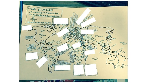
Below is a photo of an example I did, and below that a blank outline map that will print on "normal" 8.5X11 inch paper to print at home if you'd like. Remember it will be much larger when I give it to you.
Pre-AP World Geography FINAL EXAM!
It is time to show me how much you have grown and learned this year at HSPVA. It is a lot – a whole book of stuff and more!
Your geography final will be a different than a regular test. Basically it is an annotated world map, in which you can showcase your geographic knowledge. Here is how it works…
1. You will be given a large 11X17 paper with the continents outlined for you.
2. USING BLACK INK and CAPITAL LETTERS, you will identify as many places as you can, such as continents, countries, oceans, rivers, lakes, etc. You will receive .5 pts for each of these labels for a total possible 40 pts. Therefore 80 correct identifications will be the most you will receive credit for…you may do more if you are worried about getting others wrong, but you will max out at 80 correct identifications.
3. USING BLUE INK and lower case letters (except the first letter of proper nouns, etc.) you will provide annotations on the map linked to geographic location. These are worth 2 pts each for a total of 60 pts. Therefore 30 correct annotations will be the most you will receive credit for…you may do more if you are worried about getting others wrong, but you will max out at 30 correct annotations.
40 pts of identifications plus 60 pts of annotations = 100 pts.
Below is a photo of an example I did, and below that a blank outline map that will print on "normal" 8.5X11 inch paper to print at home if you'd like. Remember it will be much larger when I give it to you.
| blankoutlineworld.pdf |